
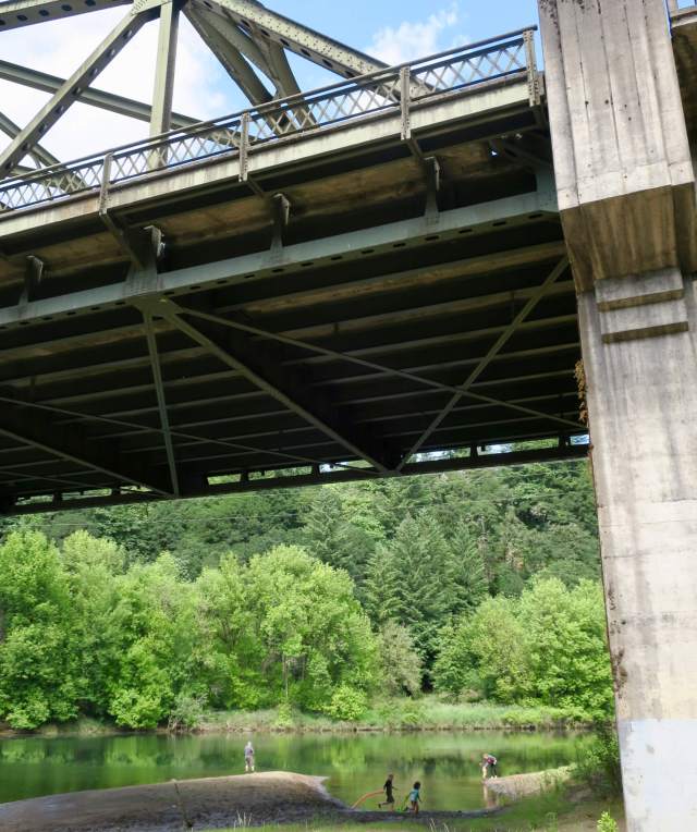
We’ve probably driven across the I-5 bridge over the Lewis River hundreds of times on our way between Olympia and Portland. Before stopping at Paradise Point State Park, though, we had no idea that a popular swimming spot and campground lay just underneath the freeway. With a few hours to spare on a recent trip, we stopped to check it out.
Look up! It’s the interstate
The park lies next to and underneath Interstate 5. An interpretive sign noted that the state purchased the first parcel to create the park in 1958, so my guess is that this park was intended as a place for travelers on the new interstate (begun in 1957) to stop on road trips. It’s a perfect location on the pretty Lewis River, less than 20 miles north of Portland. I imagine families stopping for a picnic lunch or an overnight in one of the forested campsites.
When we parked under one of the bridge spans and opened the car doors, the noise was all-encompassing. For a moment, I wondered why anyone would consider this a reasonable spot for a picnic. But then I started thinking about how traffic has changed since the park’s creation, and that got me curious about traffic volumes.
Luckily, the Washington State Department of Transportation has historical records tracking average daily traffic across the state. In 1957, this stretch of highway saw an average of 10,100 cars per day. In 2016, the latest year for which numbers are available, that number rose to 76,837 cars per day.
Let’s assume that most traffic occurs between 8am and 8pm. That works out to about 841 cars per hour in 1957, but 6,403 cars per hour in 2016. Or, to get more granular — and I realize that cars don’t travel in neatly timed clumps, but bear with me here — that means a visitor to Paradise Point in 1957 would have heard an average of 14 cars per minute, while a visitor in 2016 would have heard 106 cars per minute.
Fourteen cars per minute would have barely registered, I’m guessing. But as Mr. Adventure and I explored the area right under the bridge, I can tell you that 106 cars per minute — that’s about two cars each second — is a hell of a lot of cars and noise.

Nevertheless, we saw plenty of people enjoying the Lewis River as it drifted past. Two little mud-covered kids ran around, shouting with glee while their dad fished and mom wrangled a baby nearby. A kayaker pulled up and hauled his boat down to the shore. A little way downstream, another family fished. The noise doesn’t exactly add to the atmosphere, but I can see why this is a popular spot.

A unique disc golf course and a secret viewpoint
West of the bridge and just south of the river is a big meadow with a disc golf course. One of the targets is right under the interstate bridge, which all by itself is an attraction worth stopping for. It’s got to be the only one like it in the country.

Up the road a bit is a short hiking trail through a very green forest that provides peek-a-boo views of the traffic racing by below. As a driver on I-5, I had no idea the trail existed, but I’ll definitely be keeping an eye out for hidden hikers from now on.

The quieter part of the park
The park widens as its boundary follows the Lewis River, which is shaped vaguely like an upside-down “v” through the park. The tip of the “v” is Paradise Point. The river comes in from the southeast, and the land between it and the highway contains the campground and main hiking trails. As we headed into the forest toward the campground, the noise abated.

The trail leads through a fern-carpeted forest, and I wondered whether some of the big trees had been spared because of their proximity to the highway. The path passes a waterfall (there’s a viewing platform, but it’s closed for repairs) and down to the river. The further we walked, the quieter it became.


Along the Lewis River
When we reached the river, we could hear only a faint hum from the highway, now buffered by a forested ridge. The trail shifted from forest duff to shoulder-high grass, my least-favorite type of hiking but entirely expected along a river. Thinking of ticks, I was moving pretty fast when something across the river caught my eye. A tree was shaking violently, but I couldn’t see what was causing it. I found a clear spot on the river bank and squinted across. Maybe a bear after some early fruit? No such luck. It was a determined deer, pulling hungrily at new growth on a fruit tree.


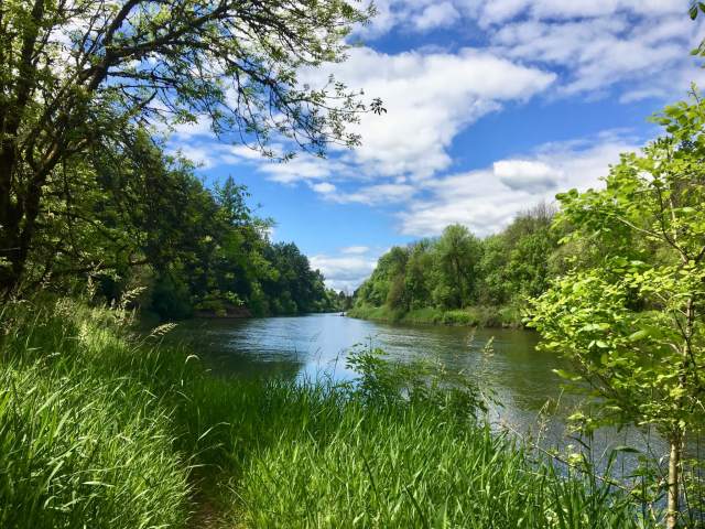
We stood on the bank a while longer, hoping to get a better look, but the lush summer growth hid the tree-munching Bambi. At last we continued along the river trail, winding up back at the parking lot underneath the bridge.
Camping at Paradise Point
We took a quick drive through the campground (bigger than I expected, with lovely forested sites) and saw a couple of yurts available to rent. As we left the campground loop, I noted the line of people waiting to register to camp. Clearly, many people know about Paradise Point’s charms. And now we do, too.

Fast facts about Paradise Point State Park
- 101-acre year-round camping park
- $10 daily parking pass (buy the annual Discover Pass, a bargain at $30)
- 6,180 feet of freshwater shoreline on the Lewis River
- hiking, bicycling, disc golf, boating, fishing, swimming (no lifeguards)
- camping and yurts (reservable online or call 888-CAMPOUT)
- picnic tables, restrooms, showers
- park brochure