We were camping with friends on the Klickitat River, a long-planned getaway in a gorgeous and uncrowded area. Our friends saddled up for a day of mountain biking, and Mr. Adventure and I headed out to explore.
We ended up at Brooks Memorial State Park, about ten miles north of Goldendale and three miles south of Satus Pass on Interstate 97. Intrigued by the unusual name, we pulled in to find out more.
The highway splits the park in two. The campground is north of the road, and we slowly drove through the RV section (rows of back-in slots in an oversized parking area) and into the woods, where tent sites were scattered among the trees. Our looky-loo attracted the attention of the camp host, who came out to intercept us as we headed back toward the entrance. This was a lucky break.
Camp host charmer
Bouncing on the balls of his feet, sporting a chin curtain beard and a kelly green cardigan, the camp host brought to mind a leprechaun, albeit one who eyed us a bit warily at first. Understandable, since we had just cruised the entire campground for no apparent reason.
“Help you folks?” he asked. We explained we wanted to explore the park and hoped to do some hiking. “Hang on a sec,” he said, and disappeared into the big RV behind him. A wooden sign hanging from a post said “Dutch & Janet,” and a small dog watched us from the front seat of the rig. “This must be Dutch,” I whispered to Mr. Adventure.
Dutch reappeared and handed us an 11×14 color satellite map of the park. “Go across the road,” he said, pointing to the map, “and drive up to where you see a little pullout, right here. There’s a trail sign across the road. Park there and head up the hill to Picnic Meadow. You’re looking for a single picnic table in the middle of the field. From there you have a view of Mount Hood.”
He told us a bit more about how the picnic table got to Picnic Meadow, which is a good story but one he made us promise not to repeat, and gave us a thumbnail history of why the park is called Brooks Memorial (keep reading). Dutch and his wife, Janet, had been seasonal camp hosts there for 10 years, he added, pausing. But she died earlier this year, he said, so now he was there on his own. We’re so sorry, we said. All three of us fell silent.
“Well, you enjoy yourselves,” Dutch said. “It’s pretty up there.” Just then, another camper wandered up, so off we went.
Through the woods to the meadow
We found the pullout, parked, and started up a wide, easy path toward Picnic Meadow. The day was sunny and cool and the air smelled of pine and green growing things. I stopped to scratch the bark of a Ponderosa pine and breathe in its vanilla scent.
One-third of a mile in, we passed a sign reading “Monastary Fire Trail” and a faint track leading into an obviously burned area. And yes, that’s how “monastery” was spelled on the rustic wooden marker, a charming reminder of how humans help make these special places accessible.


At the edge of the forest, just as it opened up, we spotted a picnic table. Climbing up on it, we couldn’t see anything but trees, including several impressive Oregon white oaks, and the meadow beyond. “This can’t be it,” Mr. Adventure said. “Let’s keep going.”
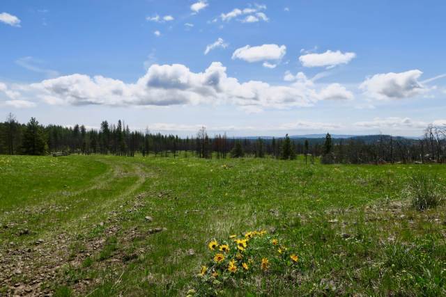
Now we were in the meadow proper, rolling swards of grass dotted with yellow in every direction. “Balsamroot!” I cried. “Look at it all!”
I am not particularly knowledgeable about plants, especially those that grow outside the maritime climate zone around Puget Sound, but I know balsamroot. One of our camping companions is a biologist, and balsamroot is her favorite spring wildflower. In springtime it covers slopes in eastern Washington, and it was flourishing in Picnic Meadow.
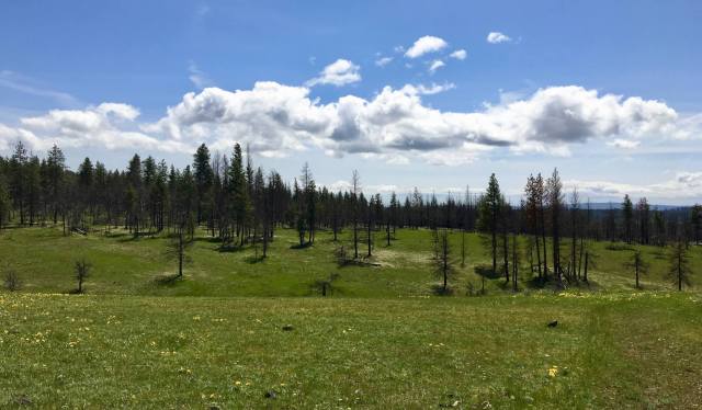
A little further on, Mr. Adventure spotted our destination, a picnic table in the middle of Picnic Meadow. The clouds hid Mount Hood from our view, but we could see some snow-dusted ridges nearby.


More trail, please
We’d reached our destination but wanted to hike more. Our map showed a network of trails, and we decided to try to make a loop back to the car through the burn area.
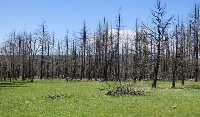
Continuing on the trail, we reached the far edge of the meadow and could see burned trees. Crossing a creek, we followed the increasingly faint trail until it ended at a fallen tree. Beyond it, no sign of a trail. And we hadn’t seen any cutoffs, either, but our map promised a trail through the burn area.
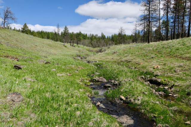
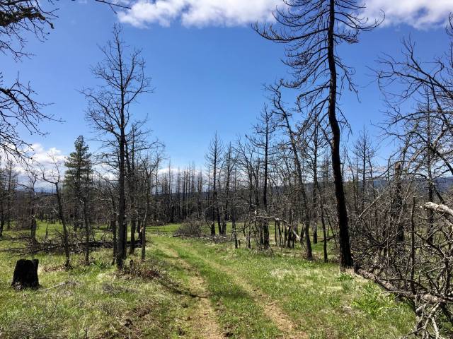
The Monastery Complex Fire burned in September 2011, forcing several hundred people to evacuate. Its name comes from St. John’s Greek Orthodox Monastery just west of the park. As the fire approached the monastery buildings, the resident nuns took up hoses and joined the firefighters. The fire ultimately burned more than 3,600 acres and destroyed more than 100 structures. The blackened trees surrounding us bore witness to the conflagration.
Follow the flags
We doubled back, looking carefully for turnoffs. “There!” Mr. Adventure shouted, pointing to a microscopic piece of pink tape tied to a branch. “And there! It’s this way.”
“You lead,” I said. We both know that while I’m good at finding my way around cities, Mr. Adventure’s sense of what’s where in the backcountry is superior. We picked our way along, following small pink tape flags until we reached a slope above the creek we’d crossed a mile or so back. To the south we could see a clear trail that seemed to head up the slope across from us.
We stepped across the creek and angled upslope to meet the trail, and found yet more pink flags. Walking through the burn was sobering. Fires are necessary for forest health, but their violence is apparent in the scarred landscape left behind. The grass underfoot glowed spring green, the sky overhead arced blue, and the trees stood blackly between. Happily, a group of six deer bounded ahead of us, testimony to the forest’s regeneration.
Eventually we came out at the Monastary Fire Trail sign we’d passed on the way to Picnic Meadow, and then back to the car.
Why Brooks Memorial?
We’d had an excellent adventure, topped off with a stop at the St. John’s Monastery Bakery and Cafe for a post-hike snack and a box of baklava to share back at camp. But I wanted to know more about Mr. Brooks, for whom the park is named.
Thank you, interwebs. Turns out Judge Nelson B. Brooks was one of the area’s most prominent and well-regarded pioneers. He emigrated with his family to Oregon in 1873, when he was 15 years old. In 1880, he filed a homestead claim in High Prairie, about 25 miles southwest of what is now his namesake park. In the way that pioneers often seem to fill many roles, during his busy life Brooks was a school principal, county school superintendent, lawyer, representative to Washington’s territorial legislature, superior court judge, council member, adjutant in the Washington National Guard, and mayor of Goldendale. He worked to bring railroad connections and good roads to the area, belonged to numerous service clubs and fraternal organizations, led bond drives during World War I, and taught Sunday school.
An obituary, published in the Goldendale Sentinel about a week after his death in June 1928, listed many out-of-town attendees at Brooks’s funeral, including our old friend Sam Hill, who looms large in area history and who’s made an appearance in my posts about Peace Arch State Park and Maryhill State Park. The writer paid unstinting tribute to Brooks: “His life has been largely identified with the upbuilding of Goldendale and Klickitat county, and he has at all times given unsparingly of his time and means toward that end, taking an active part in all matters of civic and community work.” It doesn’t mention whether the man actually slept.
I suspect Judge Brooks would be pleased with the park named for him. We sure were. There’s a stone monument honoring him in the park, but we didn’t see it, and at the time, we wouldn’t have appreciated it. Now we know better.
Fast facts about Brooks Memorial State Park
- 682-acre, camping park, open April-October
- $10 daily parking pass (buy the annual Discover Pass, a bargain at $30)
- hiking trails, equestrian trails, mountain biking
- amphitheater, sports field, horseshoe pits, swing set
- picnic tables, kitchen shelters, restrooms
- 55 campsites, group campsite, reservable online or call 888-CAMPOUT
- Environmental Learning Center available for group and event rental, with cabins for overnight stays. Reserve online (click the “Retreat Centers” tab) or call 800-360-4240 for information.
- park map
- park brochure

I love your pictures and commentary. You and Mr. Adventure captured the beauty of flowers and forest which mark this area above the Columbia.
Thanks for sharing your adventures with others.
Thanks so much, John. It is really a gorgeous area and we are looking forward to returning!